Policy 7.29 The River Thames
Policy
Strategic
A The River Thames is a strategically important and iconic feature of London. This role should be protected and promoted.
Planning decisions
B Development proposals within the Thames Policy Area identified in LDFs should be consistent with the published Thames Strategy for the particular stretch of river concerned.
LDF preparation
C Following appraisal in accordance with the criteria in paragraph 7.90 Thames-side boroughs should identify a Thames Policy Area within their LDFs and formulate policies and a strategy for this area covering the matters set out in paragraphs 7.93 and 7.94. Boroughs are encouraged to work in subregional partnerships to progress this work. The existing Thames Strategies have identified a range of actions and planning priorities that should be reflected in relevant LDFs.
Supporting text
7.87 The River Thames is one of London’s icons and merits special attention. The river changes a great deal in its size and character as it flows through London, particularly given the twice daily changes brought by the tidal nature of the river.
7.88 The central London stretches of the Thames are world famous locations, featuring well known landmarks and views. Many other stretches have important historic, cultural and natural connections. These aspects of the Thames should be protected.
7.89 As outlined in policies 7.25, 7.26 and 7.27, there are opportunities to increase the role that the Thames plays in transport terms. The Mayor believes that river transport should be increased within sustainable limits, and that owners and users of riverside sites should consider how they could contribute to or benefit from river transport.
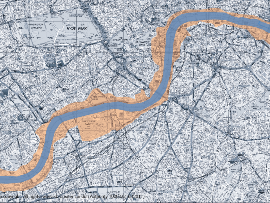
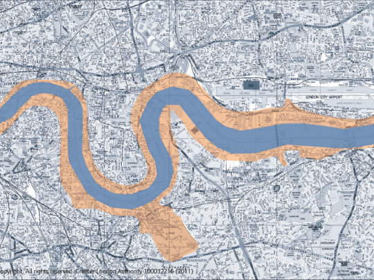
7.90 The Thames is a borough boundary for the vast majority of its length, therefore coordinated planning approaches are essential. The Thames Policy Area is a well-established tool for ensuring this co-ordination. Setting the boundary of the Thames Policy Area should be done in consultation with neighbouring authorities, including those across the river. In defining the boundaries, boroughs should have regard to maps 7.6-7.9 at the end of this chapter and the following criteria:
- proximity to the Thames, including its tributaries and associated areas of water such as docks, canals, filter beds and reservoirs, whether or not directly linked to the Thames, but where an association with the Thames is retained together with a proportion of open water
- contiguous areas with clear visual links between areas/buildings and the river, including views from across the river and areas where it may be beneficial to establish future visual links
- specific geographical features – such as main roads, railway lines, hedges, identified as particularly relevant for defining the boundary across large open spaces
- the whole curtilage of properties or sites adjacent to the Thames, except where major development sites have been identified and it is intended to publish master plans/strategies for future development
- areas and buildings whose functions relate or link to the Thames and/or river-related uses or sites that have the potential to be linked
- areas and buildings that have an historic, archaeological or cultural association with the Thames, including planned vistas marked by existing or former landscape features
- boundaries should have coherence with neighbouring authorities.
7.91 Boroughs are encouraged to carry out appraisal, Thames Policy Area designation and policy and strategy formulation in collaboration with other boroughs, and relevant stakeholders. There are three existing partnerships within London that have delivered strategies for the Thames in their stretches of the river. These are:
- Thames Strategy Hampton–Kew
- Thames Strategy Kew-Chelsea
- Thames Strategy East
7.92 These strategies provide a good sub-regional context in which decisions relating to the planning and management of the river can be set. Furthermore, all of the strategies are supported by the key regional/national stakeholders. The Mayor encourages all of the relevant boroughs to participate in the strategies and for the boroughs between Vauxhall Bridge and Tower Bridge to take a similar sub-regional overview of their high profile stretch of the Thames.
7.93 The strategies should be reviewed regularly and would be expected to consider:
- the local character of the river
- water-based passenger and freight transport nodes (both existing and potential)
- development sites and regeneration opportunities
- opportunities for environmental and urban design improvements
- sites of ecological or archaeological importance
- areas, sites, buildings, structures, landscapes and views of particular sensitivity and importance
- focal points of public activity
- public access
- recreation and marine infrastructure
- indicative flood risk.
7.94 They should also identify areas of deficiency, and the actions needed to address these deficiencies, through facilities for:
- water-based passenger, tourism and freight transport
- water-based sport and leisure
- access and safety provision
- marine support facilities and infrastructure and moorings.
7.95 The strategies should be used as guidance for LDFs and development control decisions. They also include specific implementation projects for local authorities and other organisations in a position to implement river-related projects. They should also be used to identify important riverside sites and determine the river-related expectations for them. As such, the strategies should be expressed through DPD policies or SPD as appropriate.
7.96 As part of major development proposals for sites with a Thames frontage, consideration should be given to the need and desirability of having facilities to enable access to and from the river, both for boats and for pedestrians. This may include the retention, refurbishment or reinstatement of existing or former access points or the provision of new facilities. Along the Thames in east London there are locations where a large amount of development is envisaged in opportunity areas. Some of these locations offer the opportunity for creating significant public open spaces, which should be pursued. These may be dovetailed with the need to allow a margin of land for future flood defences.
7.97 In some parts of London the Thames is designated as open space, for example as Metropolitan Open Land or falls within conservation areas. In areas where it is likely to be feasible to increase transport use of the river, such designations need careful consideration such that they do not hinder or prevent the development of and improvements to these water-based uses.
7.98 During the lifetime of this London Plan the Thames Tideway Sewer Tunnels will be constructed (see Policy 5.14). These should be designed to minimise impacts on the river, maximise water based freight and consider permanent uses for any required infrastructure such as jetties.
Map 7.6: Thames Policy Area Hampton to Wandsworth

Map 7.7: Thames Policy Area Wandsworth to Bermondsey

Map 7.8: Thames Policy Area Bermondsey to Woolwich

Map 7.9: Thames Policy Area Woolwich to Crayford Ness

Need a document on this page in an accessible format?
If you use assistive technology (such as a screen reader) and need a version of a PDF or other document on this page in a more accessible format, please get in touch via our online form and tell us which format you need.
It will also help us if you tell us which assistive technology you use. We’ll consider your request and get back to you in 5 working days.